Central Province (Kenya)
| Central Province | |
|---|---|
| — Province — | |
 |
|
| Coordinates: | |
| Country | |
| No. of districts: | 12 |
| Capital | Nyeri |
| Area | |
| - Total | 13,191 km2 (5,093.1 sq mi) |
| Population (2007) | |
| - Total | 4,145,000 |
| Time zone | EAT (UTC+3) |
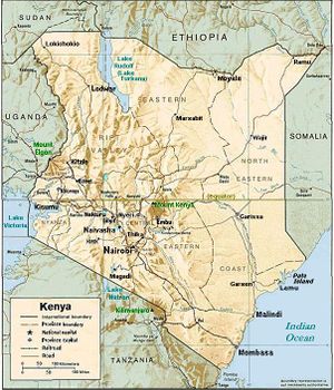
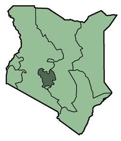
Kenya's Central Province covers the area around its capital city, Nyeri, to southwest of Mt. Kenya (see maps). It is the ancestral home of, among others, the g.e.m.a. communities. According to the 2007 estimates, the province had a total population of 4,145,000 inhabitants for an area of 13,191 km².
Contents |
Climate
The climate of Central Province is generally cooler than that of the rest of Kenya, due to the region's higher altitude. Rainfall is fairly reliable, falling in two seasons, one from early March to May (the long rains) and a second during October and November (the short rains).
General information
Central Province is a key producer of coffee, one of Kenya's key exports. Much of Kenya's dairy industry is also based in this province. The province's headquarters are in Nyeri. Central Province was divided into seven districts (wilaya'at) until 2007. The general dressing style is trousers and shirts for men and dresses or skirts for the women. The people usually have scraps of cloth tied to their foreheads during the hot days.[1]:
| District | Population | Capital |
|---|---|---|
| Nyandarua | 479,902 | Ol Kalou* |
| Nyeri | 661,156 | Nyeri |
| Kirinyaga | 457,105 | Kerugoya |
| Maragua | 387,969 | Maragua |
| Murang'a | 348,304 | Murang'a |
| Thika | 645,713 | Thika |
| Kiambu | 744,010 | Kiambu |
| * former capital: Nyahururu | ||
Districts after 2007
Several new district have been created created since in 2007 in Kenya, including several in Central Province [2]:
| District | Capital |
|---|---|
| Gatanga | Gatanga |
| Gatundu | Gatundu |
| Gatundu North | Kamwangi |
| Githunguri | Githunguri |
| Kabete | Kikuyu |
| Kandara | Kandara |
| Kiambu East (Kiambaa) | Kiambu |
| Kiambu West | Limuru |
| Kieni East | Chaka |
| Kieni West | Mweiga |
| Kigumo | Kigumo |
| Kinangop | Engineer |
| Kirinyaga Central | Kerugoya |
| Kirinyaga East | Kianyaga |
| Kirinyaga South | Wanguru |
| Kirinyaga West | Baricho |
| Lari | Lari |
| Maragua | Maragua |
| Mathioya | Kiria-ini |
| Mathira East | Karatina |
| Mathira West | Kaiyaba |
| Mirangini | Mirangini |
| Mukurweini | Mukurweini |
| Murang'a North | Murang'a |
| Murang'a South | Kenol |
| Nyandarua Central | Ol Kalou |
| Nyandarua North | Nyahururu |
| Nyandarua South | Njambini |
| Nyandarua West | Ol Jororok |
| Nyeri Central | Nyeri |
| Nyeri South | Othaya |
| Ruiru | Ruiru |
| Tetu | Wamagana |
| Thika East | Gatuanyaga |
| Thika West | Thika |
History
The province is inhabited by the Kikuyu speaking community almost exclusively . this are part of the Kenya Eastern Bantu.
During Kenya's colonisation by the British, much of the province was regarded as part of the 'White Highlands' for the exclusive use of the settler community. Thus it was prone to a lot of political activity from the local communities who felt that they had an ancestral right to the land. This culminated in the 1950s with the Mau Mau rebellion that saw the region placed under a state of emergency and the arrest of many prominent political leaders.
See also
- Ruiru
|
|||||||||||